The region south of the Alps covers a wide range of elevations. In the lowest-lying areas, along the lakes at 200–300 m a.s.l., the number of summer days and tropical nights will increase considerably. Even now, days with fresh snowfall are quite rare in these areas. In the future, there could be winters with practically no snow at all at this elevation if greenhouse gas emissions continue to increase at current rates.
The figures below illustrate the changes in four climate parameters at four elevations south of the Alps. The altitude levels are shown in the right-hand half of the charts. The vertical black lines in the charts denote the recorded average from the normal period (1981 to 2010). The coloured bars indicate the possible range of the climate parameter in question for the two emission scenarios RCP2.6 and RCP8.5 during the period around 2060. The vertical coloured lines show the median value over the simulations with different climate models and represent the expected value.
What do RCP2.6 and RCP8.5 mean? You can find an explanation of the emission scenarios here.
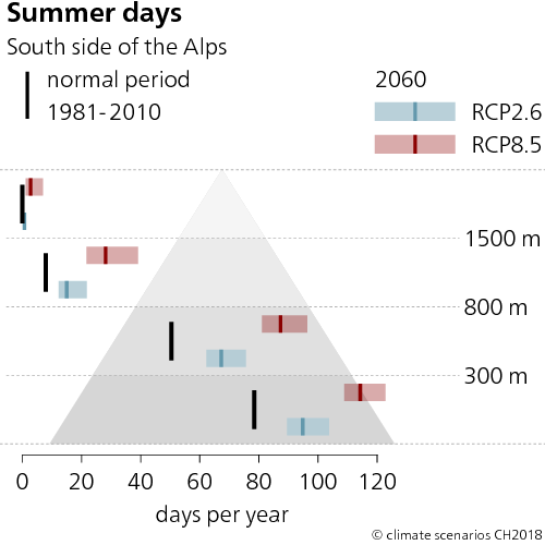
Summer days now
In the low-lying areas of southern Switzerland below 300 m a.s.l., there are currently around 80 summer days; in the highest areas, there are none.
Summer days around 2060
Without climate change mitigation (RCP8.5), the low-lying areas can be expected to have an average of around 115 summer days per year by the middle of the century. Even at elevations above 1,500 m a.s.l., some summer days per year will be possible. With climate change mitigation (RCP2.6), the number of summer days in the lowlands can be limited to just under 100.
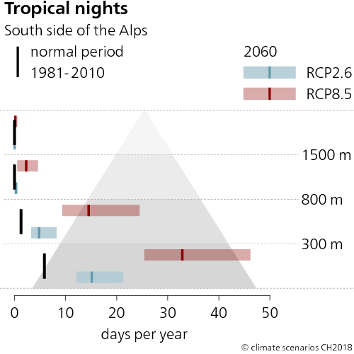
Tropical nights now
In the lower-lying areas of southern Switzerland, there are around 6 tropical nights per year in the present climate. Above 300 m a.s.l., tropical nights are a rare occurrence.
Tropical nights around 2060
Without climate change mitigation (RCP8.5), by the middle of this century, more tropical nights per year can be expected on average at elevations of up to 1,500 m a.s.l. The increase will be particularly pronounced at elevations below 800 m a.s.l. At the lowest elevations, about 30 tropical nights per year are expected. The increase can be limited to 15 additional nights if climate change mitigation measures are implemented.
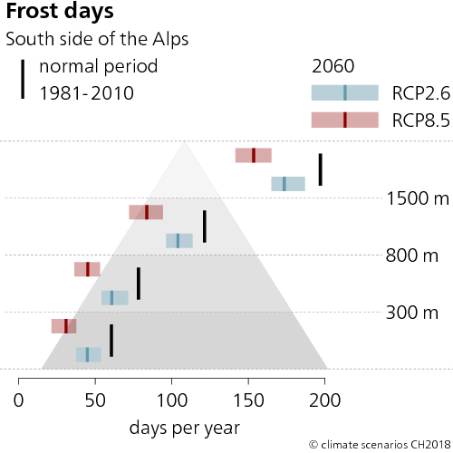
Frost days now
The lowest elevations currently observe around 60 days of frost. Elevations above 1,500 m a.s.l. experience around 200 frost days per year.
Frost days around 2060
Without climate change mitigation (RCP8.5), the low-lying areas can be expected to have an average of around 30 frost days per year by the middle of the century, whereas areas above 1,500 m a.s.l. can expect around 150. With mitigation (RCP2.6), there would still be around 45 frost days at lower elevations and 175 at higher elevations.
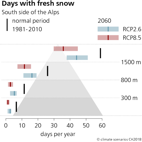
Days with fresh snow now
In the low-lying areas, there are currently 7 days of fresh snowfall per year on average. At elevations above 1,500 m a.s.l., there are around 60.
Days with fresh snow around 2060
Without climate change mitigation (RCP8.5), in the low-lying areas there will be scarcely any days with fresh snow by the middle of the century, whereas areas above 2,500 m a.s.l. can expect just under 35. With climate change mitigation (RCP2.6), the decrease is less drastic: There would be around 5 days of fresh snowfall at lower elevations, and just under 45 at higher elevations.
Last modification 11.12.2018