Jura

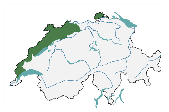
The major region of Jura stretches from Lake Geneva to the two Basel cantons and those of Solothurn and Schaffhausen. This page provides insights into today’s climate in the Jura region as well as detailed information about possible changes in the future.

A map of Switzerland is shown with the outline of the region of Jura. This includes parts of the cantons of Vaud, Neuenburg, Bern, Jura, Basel-Landschaft, Basel-Stadt, Solothurn and Schaffhausen.
The biogeographical major region of Jura (in green), according to the Federal Office for the Environment FOEN, used to develop regional climate scenarios.

Current climate

The Jura mountains are the first region to be hit by fronts that reach Switzerland from the west. Accordingly, the average rainfall is greater than in the Central Plateau. Thunderstorms are frequent in the Jura. In the high valleys of the Jura, distinctive cold air pools can form in the winter. In summer, some summer days are possible at all altitudes of the Jura.

Climate Change Scenarios CH2018 - Jura

Without concerted efforts to mitigate climate change, temperatures in the Jura region could increase by another 2–3°C by the middle of the 21st century. As a result, the number of days with fresh snowfall will decrease, and frost days will become less common. Winter precipitation is likely to increase by 5–28%, and the summer months will become drier.

Last modification 07.09.2023

Top of page

Contact

Federal office of meteorology and climatology MeteoSwiss
Operation Center 1
P.O. Box
CH-8058 Zurich-Airport

Contact

Print contact

https://www.nccs.admin.ch/content/nccs/en/home/regionen/grossregionen/jura.html