The Pre-Alps cover an elevation range from 400 to 2,500 metres above sea level. The region is strongly affected by a decrease in the number of fresh snowfall and frost days. At medium elevations, the number of summer days will double if greenhouse gas emissions continue to rise unchecked. Tropical nights can no longer be completely ruled out, even at higher elevations.
The figures below illustrate the changes in four climate parameters at four elevation levels in the Pre-Alps. The altitude levels are shown in the right-hand half of the charts. The vertical black lines in the charts indicate the observed average in the current climate (normal period of 1981–2010). The coloured bars denote the possible range of the climate parameter in question for the two emission scenarios RCP2.6 and RCP8.5 during the period around 2060. The vertical coloured lines show the median value across the simulations with different climate models and represent the expected value.
What do RCP2.6 and RCP8.5 mean? You can find an explanation of the emission scenarios here.
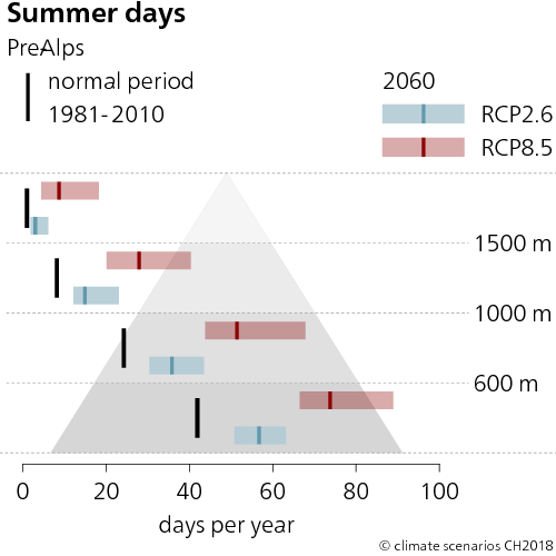
Summer days now
In the lower-lying regions below 600 m a.s.l., there are currently 42 summer days per year. Above 1,500 m a.s.l., summer days are rare; they occur in these areas on average once a year.
Summer days around 2060
Without climate change mitigation (RCP8.5), summer days will increase across the entire region until the middle of the century. At the lowest elevations, about 75 summer days per year are expected. Areas above 1,500 m a.s.l. can expect around 10 summer days. With climate change mitigation (RCP2.6), the number of summer days below 600 m a.s.l. can be limited to about 60.
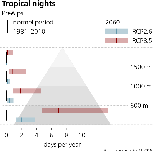
Tropical nights now
At present, tropical nights are still a very rare event even in the lowest areas of the Pre-Alps, occurring, if at all, in conjunction with the Föhn. Thus, on average, no tropical nights occur at all at any given elevation.
Tropical nights around 2060
Without climate change mitigation (RCP8.5), in an average year, there may be around 7 tropical nights at lower elevations by the middle of the century. With climate change mitigation (RCP2.6), tropical nights would remain a rarity in the Region.
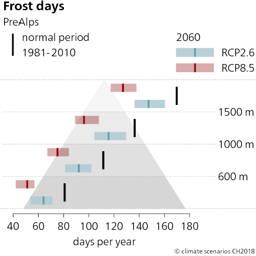
Frost days now
The lowest elevations record around 80 days of frost. The number of frost days increases with altitude, averaging 170 days for the highest elevations above 1,500 m a.s.l.
Frost days around 2060
Without climate change mitigation (RCP8.5), the low-lying areas can be expected to have an average of around 50 frost days per year by the middle of the century, whereas areas above 1500 m a.s.l. can expect around 130. With climate change mitigation (RCP2.6), there would be around 60 frost days at lower elevations and 150 at higher elevations.
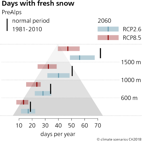
Days with fresh snow now
Above 1,000 m a.s.l., there are between 50 and 70 fresh snowfall days per year. In the low-lying areas, there are currently 20 days of fresh snowfall on average.
Days with fresh snow around 2060
Without climate change mitigation (RCP8.5), the low-lying areas can be expected to have an average of just under 15 Days with fresh snowfall per year by the middle of the century, whereas areas above 1,500 m a.s.l. can expect just under 50. With mitigation (RCP2.6), there would be 17 days of fresh snowfall at lower elevations and 56 at higher elevations.
Last modification 11.12.2018